On May 17, 1673, Louis Jolliet and Jacques Marquette departed from St. Ignace, Michigan, with two canoes and five other voyageurs of French-Indian ancestry. The group sailed to Green Bay. They paddled upstream (southward) on the Fox River to the site now known as Portage, Wisconsin. There, they portaged a distance of slightly less than two miles through marsh and oak forest to the Wisconsin River. Europeans eventually built a trading post at that shortest convenient portage between the Great Lakes and Mississippi River basins. On June 17, the canoeists ventured onto the Mississippi River near present-day Prairie du Chien, Wisconsin.
The Jolliet-Marquette expedition paddled along the west bank of the Mississippi until mid-July. When they passed the mouth of the Arkansas River, they became satisfied that they had established that the Mississippi flowed into the Gulf of Mexico.
The voyageurs then followed the Mississippi back to the mouth of the Illinois River, which friendly natives told them was a shorter route back to the Great Lakes. Following the Illinois river upstream, they turned up its tributary, the Des Plaines River near modern-day Joliet, Illinois. They continued up the Des Plaines River and portaged their canoes, and gear, at the Chicago Portage. They followed the Chicago River downstream until they reached Lake Michigan near the location of modern-day Chicago. Father Marquette stayed at the mission of St. Francis Xavier at the southern end of Green Bay, which they reached in August. Jolliet returned to Quebec to relate the news of their discoveries. On his way through the Lachine Rapids, Jolliet’s canoe overturned and his records were lost. His brief narrative, written from memory, is in essential agreement with Marquette’s, the chief account of the journey.
While Hernando de Soto was the first European to make official note of the Mississippi River by discovering its southern entrance in 1541, Jolliet and Marquette were the first to locate its upper reaches and, travel most of its length, about 130 years later. De Soto had named the river Rio del Espiritu Santo but, tribes along its length called it “Mississippi”, meaning “Great River” in the Algonquian languages.
Also known as the Second Treaty of Indian Springs or Treaty with the Creeks, one-hundred, ninety-five years ago, today, it was signed by the Muscogee and the U.S. government at the Indian Springs Hotel (now a museum).
The U.S. and the Muscogee had, previously, signed the Treaty of Indian Springs of 1821. On January 8, the Muscogee agreed to cede their land holdings east of the Flint River to the state of Georgia in exchange for $200,000, paid in installments.
[…] Duncan Campbell and James Meriwether, U.S. Commissioners, [wrote] to Georgia Governor George M. Troup regarding obstacles the commissioners [faced] in treating with the Creeks. They [related] that proceedings [were] being conducted orally since the written method [had] failed. Also, the publication of negotiations held at Tucabatchee (Tuckabatchee or Tuckabatchie) and Pole Cat Springs [had] spread alarm throughout the nation as [had] the persistent “interference” of the Cherokees. Campbell and Meriwether negotiated the Treaty of Indian Springs [of] 1825 that was unauthorized by a majority of Creeks and, later, abrogated by the United States.
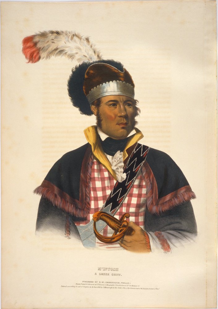
Image Credit: Georgia Encyclopedia William McIntosh
Tustunnuggee Hutke (White Warrior)
The treaty that was agreed [to] was negotiated with six chiefs of the Lower Creek, led by William McIntosh. McIntosh agreed to cede all Muscogee lands east of the Chattahoochee River, including the sacred Ocmulgee National Monument (Historic Park), to Georgia and Alabama and, accepted relocation west of the Mississippi River to an equivalent parcel of land along the Arkansas River. In compensation for the move to unimproved land, and to aid in obtaining supplies, the Muscogee nation would receive $200,000 (again), paid in decreasing installments over a period of years. An additional $200,000 was paid directly to McIntosh.
Outcome:
Governor Troup, and most Georgians, were in favor of the treaty and his inside man was his first cousin…William McIntosh. McIntosh paid the highest price. According to a Creek law, that McIntosh, himself, had supported, a sentence of execution awaited any Creek leader who ceded land to the United States without the full assent of the entire Creek Nation. Just before dawn on April 30, 1825, Upper Creek chief Menawa, accompanied by 200 Creek warriors (The Law Menders), attacked McIntosh at Lockchau Talofau (Acorn Bluff/McIntosh Reserve) to carry out the sentence. They set fire to his home, shot and stabbed him to death and, [killed] the elderly Coweta chief Etomme Tustunnuggee. Chillie McIntosh, the chief’s oldest son, had also been sentenced to die but, he escaped by diving through a window. Later that day, the Law Menders found [Samuel and Benjamin Hawkins, Jr.] (McIntosh’s sons-in-law), who were also signatories. They hanged Samuel and shot Benjamin but, he escaped.
A large majority of chiefs and warriors objected that McIntosh did not have sufficient authority to sign treaties or cede territory. [The] Creek Nation sent a delegation, led by Opothleyahola and [included] Menawa, to lodge an official complaint. Federal investigators (appointed by President John Quincy Adams) agreed and the U.S. government negotiated a new land cession in the 1826 Treaty of Washington. The Creeks did not, however, have their territory restored in the new treaty.
Though the Creek did retain a small tract of land on the Georgia-Alabama border and the Ocmulgee National Monument, Governor Troup refused to recognize the new treaty. [He] authorized all Georgian citizens to evict the Muscogee and ordered the land surveyed for a lottery, including the piece that was to remain in Creek hands. He threatened an attack on Federal troops if they interfered with the [previous] treaty and challenged [the President]. The president intervened with Federal troops but, Troup called out the state militia, and Adams, fearful of a civil war, conceded.