the atlantic
Flashback Friday: Joplin Tornado 2011
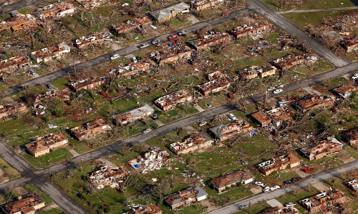
Nine years ago, today, an EF5, multi-vortex tornado slammed into Joplin, Missouri. It formed at 5:34 pm CDT and dissipated at 6:12pm CDT. I remember this one, vividly. I had just moved back to North Carolina from Texas and was, literally, still unpacking. I was shocked at the devastation. ~Vic
[This] was part of a larger, late May tornado outbreak and reached a maximum width of nearly one mile […] during its path through the southern part of the city. This particular tornado was unusual in that it intensified in strength and grew larger in size at a very fast rate. The tornado tracked eastward across the city and, then, continued eastward across Interstate 44 into rural portions of Jasper County and Newton County. It was the third tornado to strike Joplin since May 1971.
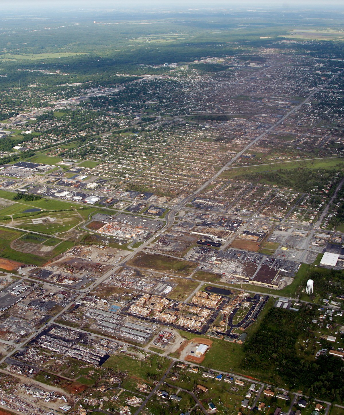
[The] tornado killed 158 people (with an additional eight indirect deaths), injured some 1,150 others and caused damages amounting to a total of $2.8 billion. It was the deadliest tornado to strike the United States since the 1947 Glazier–Higgins–Woodward tornadoes, and the seventh-deadliest overall. Along with the Tri-State Tornado and the 1896 St. Louis–East St. Louis tornado, it ranks as one of Missouri’s and America’s deadliest tornadoes […]. It was the first F5/EF5 tornado in Missouri since May 20, 1957 [and] was only the second F5/EF5 tornado in Missouri history dating back to 1950.
It also ranks as the costliest single tornado in U.S. history.
Additional Reading & Sources:
May Tornadoes Struck Joplin Twice in the 1970s (Joplin Globe)
Joplin Tornado (National Weather Service)
F5 & EF5 Tornadoes of the US (NOAA)
Tornado Damaged Joplin From Above (The Atlantic)
Joplin Tornado (Tornado Facts Site)
2011 Joplin Tornado (Wikipedia)
Mike Bettes Has A Hard Time
Throwback Thursday: Sverdlovsk Anthrax Leak 1979

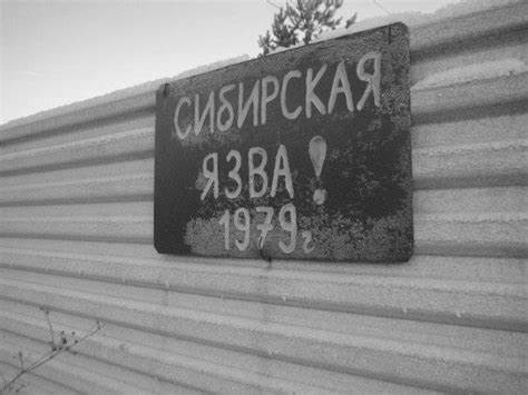
Forty-one years ago, today, spores of anthrax were accidentally released from a Soviet military research facility near the city of Sverdlovsk, Russia (now Yekaterinburg/Ekaterinburg).
On April 2, 1979, there was an unusual anthrax outbreak, which affected 94 people and killed at least 64 of them, in the Soviet city of Sverdlovsk, roughly 850 miles east of Moscow. The first victim died after four days. [T]he last one died six weeks later. The Soviet government claimed the deaths were caused by intestinal anthrax from tainted meat, a story some influential American scientists found believable. However, officials in the Carter Administration suspected the outbreak was caused by an accidental release of anthrax spores from a suspected Soviet biological weapons facility located in the city (Military Compound 19). The US believed that the Soviet Union was violating the Biological Weapons Convention signed in 1972 and made their suspicions public. But, the Soviets denied any activities relating to biological weapons and, at numerous international conferences, tried to prove their contaminated meat story. It wasn’t until thirteen years later, in 1992, that President Boris Yeltsin admitted, without going into details, that the anthrax outbreak was the result of military activity at the facility. [Russia] allowed a team of Western scientists to go to Sverdlovsk to investigate the outbreak. The team visited Sverdlovsk in June 1992 and August 1993 […].
Although the KGB had confiscated hospital and other records after the incident, the Western scientists were able to track where all the victims had been at the time of the anthrax release. Their results showed that on the day of the incident, all the victims were clustered along a straight line downwind from the military facility. Livestock in the same area also died of anthrax. After completing their investigation, the team concluded the outbreak was caused by a release of an aerosol of anthrax pathogen at the military facility. But, they were unable to determine what caused the release or what specific activities were conducted at the facility.
“Clogged filter, I removed it. Replace the filter”. [A] reminder on a piece of paper left [by a] factory worker […] to his mate when he went home on Friday evening…
Colonel Nicholas Cheryshev, shift supervisor at the plant, […] was in a hurry to go home and, for some unknown reason, was not aware of the lack of filter. In the end, the workers on the night shift, finding entries in the log window, quietly launched [the] equipment. [For] more than three hours, the plant was [throwing], into the air [of] the night sky of […] Sverdlovsk, portions [of] dried culture of anthrax. When the lack of bio-security was discovered, production was urgently stopped, […] the filter [replaced] and [they], quietly, continued working.
It was an accident at a clandestine biological weapons lab that allowed deadly anthrax spores to contaminate Sverdlovsk’s air, as evidence unearthed later would show. Over the years, as DNA sequencing technology has improved, scientists have been piecing together more and more information about the anthrax strain.
This facility has not been closed. It just went underground…literally. ~Vic
Sources & Additional Reading
Sverdlovsk Anthrax Leak (Adam Smith Institute)
1979 Anthrax Leak (PBS: Frontline)
How DNA Evidence Confirmed A Soviet Cover-Up (The Atlantic)
The Tragedy of Sverdlosk-19 (Weapon News)
Biohazard Book (Wikipedia)
Sverdlovsk Anthrax Leak (Wikipedia)
Wayback Wednesday: Tybee Island Bomb Accident 1958

Silkscreen Image For T-shirts
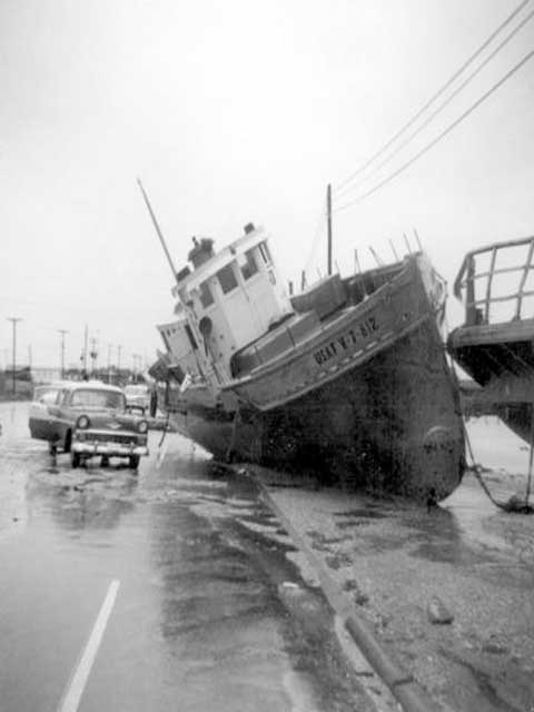
America lost a bomb. I’m not kidding. Sixty-two years ago, today, the United States Air Force dropped a nuclear bomb in the water off the coast of Tybee Island, very close to Savannah, Georgia. A North American Aviation F-86 Sabrejet fighter plane and a Boeing B-47 Stratojet strategic bomber collided during practicing exercises and, in fear of a detonation in the event of a crash, the crew jettisoned the bomb. They still haven’t found it and it is assumed to be somewhere at the bottom of Wassaw Sound.
The B-47 bomber was on a simulated combat mission from Homestead Air Force Base in Florida. It was carrying a single 7,600-pound bomb. At about 2:00am EST, an F-86 fighter collided with the B-47. The F-86 crashed after the pilot ejected from the plane. The damaged B-47 remained airborne, plummeting 18,000 feet from 38,000 feet when [the pilot] regained flight control. The crew requested permission to [drop] the bomb in order to reduce weight and prevent the bomb from exploding during an emergency landing. Permission was granted and the bomb was jettisoned at 7,200 feet […]. The crew did not see an explosion when the bomb struck the sea. They managed to land the B-47 safely at […] Hunter Air Force Base. The pilot, a Colonel Howard Richardson, was awarded the Distinguished Flying Cross after this incident.

Some sources describe the bomb as a functional nuclear weapon but, others describe it as disabled. If it had a plutonium nuclear core installed, it was a fully functional weapon. If it had a dummy core installed, it was incapable of producing a nuclear explosion but, could still produce a conventional explosion. […] The Air Force maintains that its nuclear capsule, used to initiate the nuclear reaction, was removed before its flight aboard B-47. […] the bomb contained a simulated 150-pound cap made of lead. However, according to 1966 Congressional testimony by Assistant Secretary of Defense W.J. Howard, the Tybee Island bomb was a “complete weapon, a bomb with a nuclear capsule” and one of two weapons lost that contained a plutonium trigger. Nevertheless, a study of the Strategic Air Command documents indicates that Alert Force test flights in February 1958 with the older Mark 15 payloads were not authorized to fly with nuclear capsules on board.
The collision, and its aftermath, also drives the plot of the novel Three Chords & The Truth by Craig McDonald, published in November 2016.
Missing For 50 Years (BBC News)
This Day In Aviation (This site claims the bomber was from MacDill Air Force Base)
Lost H-Bomb: RIP (Savannah Now Archive)
The Case of the Missing H-Bomb (Counterpunch Archive)
The Colonel and the Bomb (The Atlantic)
Wayback Wednesday: Hurricane Carla 1961
I realize that September 11 is usually reserved for the remembrance of 9/11 but, that seems to be all over the news as it is. There are other things that have happened on September 11. ~Vic
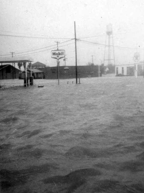
Fifty-eight years ago, today, Category 4 Hurricane Carla slammed into Texas, making landfall near Port O’Connor. She was the first Category 5 of the 1961 Atlantic hurricane season.
From the National Weather Service:
Carla was the most intense hurricane to make landfall on the Texas coast in the 20th century and second in recorded history only to the Indianola hurricane of 1886. Carla was the last of 6 hurricanes to make landfall on the Texas coast as a Category 4 hurricane on the Saffir-Simpson scale, with sustained winds stronger than 130 mph, in the 20th century. Carla ranks as the 9th most intense hurricane to affect the United States since 1851.
Carla made landfall on the afternoon of the 11th on the northeast part of Matagorda Island as a strong Category 4 hurricane […]. The eye of Carla moved across Port O’Connor and Port Lavaca and, then, inland just east of Victoria. Carla weakened to a tropical storm on the morning of the 12th just east of Austin.
Carla was an extremely large hurricane with devastating effects from the winds and storm surge […]. The extreme tides inundated downtown Port Lavaca with 2 feet of flood water and displaced fishing boats and tug boats on Highway 35. With the slow movement of Carla, the hurricane pushed a storm surge of 22 feet above mean sea level at the head of Lavaca Bay in Port Lavaca. This is the highest storm surge in Texas hurricane history.
From Wikipedia:
[Little-known] newsman Dan Rather reported live from the second floor of a building in Texas City during the storm, an act that would be imitated by later reporters. This marked the first live television broadcast of a hurricane. Rather also alerted the public of the size of Carla in a way that “literally changed the way the world sees hurricanes”, according to a fellow reporter. Broadcasting live at the Weather Bureau Office in Galveston, Rather asked a meteorologist to draw an outline of the Gulf of Mexico on a transparent sheet of plastic. He then held the map over the black and white radar screen, which put the size of Carla into perspective, saying that Carla was the size of the Gulf of Mexico. CBS was so impressed with Rather’s work that he was offered the position of correspondent.
Carla remains number one on the Hurricane Severity Index.
